
High performance, ultra-compact airborne lidar sensor for high altitude and wide area survey applications.
The Orion H300 lidar mapping system is the most versatile system, it has an incredibly wide operational envelope, making it a universal sensor with the flexibility to capture in low-altitude projects, as well as high-altitude, wide-area collections. Packed with high-performance features, the H300 offers exceptional collection efficiency and productivity, as well as industry-leading measurement accuracy to provide the best quality data sets.
The perfect combination of performance and size for those looking for a suitable lidar studio system for all application spaces.
The ALTM Aquarius is an innovative and compact solution for coastal and inland waterway mapping. Compatible with the ALTM Gemini system, Aquarius collects simultaneous terrain and shallow bathymetry measurements allowing comprehensive data sets spanning the land / water interface.
Bathymetric systems, such as the Optech Aquarius, use a green spectrum laser beam (532 nm), the beam penetrates the water and also detects the lower surface of the water under favorable conditions, the data acquisition technique includes a mapping component of the seabed and one of terrain mapping.
The mapping produces topography on land and underwater elevations; Depending on the clarity of the water, the LiDAR sensor can measure depths from 0.9 to 40 m with a vertical precision of 15 cm and a horizontal precision of 2.5 m.
Optech CZMIL Nova is an innovative airborne coastal zone mapping system that simultaneously produces high-resolution 3D images and representations of the beach and the shallow seabed, including coastal topography, benthic classification and characterization of the water column.
It performs particularly well in shallow and cloudy waters. Its bathymetric lidar is integrated with a hyperspectral imaging system and a digital metric camera that manages all three sensors, from mission planning to fused lidar and image data sets.
Better topo / bathymetric results without separations in clear water up to 70-75 m and incomparable results in cloudy water.
The iXM-RS 150F enables higher productivity for a variety of aerial imaging projects by providing broader coverage compared to other cameras. With its Ultra-High Resolution (14204 x 10652 pix) and backlight sensor, it enables perfect image quality, even in low light conditions. As a result, more flight hours per day and more flight days per year can be achieved.
With our 4-band camera we can obtain RGB photographs in addition to the infrared band and thus be able to calculate the Normalized Difference Vegetation Index (NDVI). By measuring the difference in reflectance between near infrared light (which is strongly reflected) and red light (which is absorbed), plant health can be accurately and quickly quantified and evaluated over a large area.
The TU206-A is a 300 hp turbo piston single-engine aircraft with fixed landing gear.
The combination of a powerful motor, robust construction, and a large cabin makes it the ideal aircraft for remote sensing surveys.
It has the modification to place the LIDAR remote detection systems, approved by the FAA (Federal Aviation Administration)
The 210-5 (205) is a 260 hp piston single-engine aircraft with fixed landing gear.
The combination of a powerful motor, robust construction, and a large cabin makes it the ideal aircraft for remote sensing surveys.
It has the modification to place the LIDAR remote detection systems, approved by the FAA (Federal Aviation Administration)
The Bell 206 is a lightweight observation helicopter with a capacity for 7 people.
Due to its load capacity, it is the ideal aircraft to transport remote sensing geophysical sensors together with the system operator; thus having an optimal performance.
The Teledyne Z-Boat from Ocean Science is an innovative alternative for hydrographic exploration in shallow waters, with which bathymetric levels can be obtained where conventional methods are not practical or safe.
It is a portable equipment that integrates a GPS positioning system, remote control navigation, an echo sounder and a telemetry system that allows remote communication between the operator and the boat and the sending of information in real time.
The Z-Boat can be used in studies in rivers with a fast flow, even against the current, thanks to the power of the motor that offers speeds of up to 4 knots or 2 m / s.
It is manufactured with anti-corrosion materials, making it the ideal equipment for the study, management and handling of industrial waste, such as mining tailings dams, waste ponds or leachate pits.
The multibeam system is an echo sounder whose transducer is capable of simultaneously emitting a fan of acoustic waves (256 pulses), these acoustic waves hit the bottom, bounce and the echo is detected by the receiver, separating the depth measured by each acoustic wave from the angle at which it was emitted, this process can be repeated up to 100 times per second. Additionally, background reflectivity data is recorded, with which background type maps and false image can be generated.
EM-VLF surveys are a passive electromagnetic method that uses radio transmitters within the 15 kHz - 30 kHz frequency range and which are globally distributed. During the acquisition of VLF data, the components of the magnetic field of the transmitted signal are measured, which in turn, is affected by the local conditions of the subsoil.
This aerial acquisition system is composed of 2 sensors made up of 3 perpendicular coils, which simultaneously acquire the information from two VLF transmission stations without the need to set the orientation of the sensors. The data obtained from the VLF system includes the values of the in-phase components, in-quadrature component, horizontal components, and the total field intensity in picoTesla (pT).
The GSMP-35GA3 system integrates 3 potassium vapor magnetometers, with 2 VLF sensors for electrical resistivity mapping, obtaining simultaneous information from 3 magnetic sensors, provides the opportunity to obtain the measured horizontal and vertical magnetic gradient values.
The vertical gradient is an excellent tool for detecting shallow magnetic sources, when compared to the total magnetic field signal alone. If the acquisition is performed at a low altitude and at moderate speeds, the gradiometric survey can obtain subsurface information in exceptional detail.
Advances in technology and computation make it possible, through data inversion techniques, to obtain not only a map of lateral variations in electrical conductivity, but also to obtain resistivity sections in 2D.
Teledyne RD Instruments (ADCP) 600 MHz Current Doppler Profiler, Workhorse Sentinel model. It consists of four transducers that have a 75m range, made in the USA, with internal battery, 1GB memory, depth sensor, thermometer, gyroscope and internal movement sensors. Equipped with Waves Array for wave characterization and tide level measurement.
The transducer allows knowing the depths and temperatures of the water, offering a high frequency range of (200kHz) high precision (1 cm). It can reach 75 m of maximum reading depth and 0.30 m minimum, thus obtaining more coverage under the boat.
It measures the depth of water in wells, boreholes, risers and tanks; They are rugged, easy to use, and read accurately to 1/100 feet or every millimeter.
The level gauges use corrosion-proof stainless steel probes attached to a permanently marked flat tape, mounted on a well-balanced spool.
The probes incorporate an isolation space between the electrodes, when it comes into contact with water, the circuit closes, activating a loud bell and a light; the water level is then determined by taking a reading directly from the tape on top of the well cover.
A sensitivity control allows the buzzer to turn off while in cascading water, and ensures a clear signal under both high and low conductivity conditions.
The Levelogger Edge is a standalone water level data logger, utilizing infrared data transfer powered by a 10-year lithium battery, offering installation flexibility through the use of a Direct Read Cable, traditional Cable or Kevlar cable.
The Levelogger Edge has a memory capacity of 40,000 water level and temperature data points, or up to 120,000 using the compression algorithm in linear sampling mode.
Many water level data loggers use a pressure sensor to measure the water pressure above the water level data log measurement point. Water pressure readings can be converted to equivalent water level measurements.

Airborne LIDAR Systems


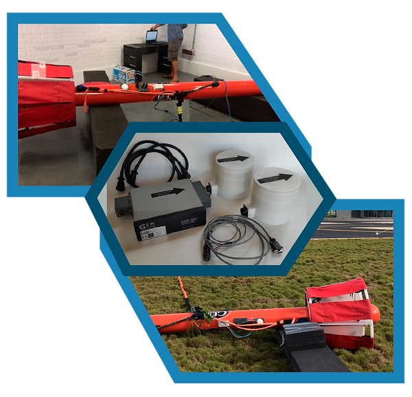
LIDAR Optech ALTM Gemini
The Gemini ALTM laser system incorporates multipulse technology that allows users to double conventional operating altitudes without compromising data density. With a rate of 167,000 pulses per second and the latest in hermetic coupling inertial technology, ALTM Gemini maximizes the efficiency of surveying your survey data.
The LiDAR mapping consists of a laser scanning system, an inertial measurement unit (IMU) and a GPS receiver that allows to reference each measurement or point in the resulting data cloud, which will be combined to create a 3D representation of the area of interest.
In general, LIDAR technology has applications in surveying, urban planning, construction projects, urban development, cadastre, etc.
LIDAR Optech ALTM Orion H300
LIDAR RIEGL LMS - Q560
The equipment is a revolutionary 2D laser scanner using the latest in digital signal processing, meeting the most demanding requirements in aerial laser scanning. The RIEGL LMS-Q560 provides access to different detailed parameters by digitizing the echo signal online during data acquisition and subsequent offline waveform analysis. This method is especially valuable when it comes to difficult tasks, such as canopy height research or target classification.
The instrument uses the time-of-flight distance measurement principle of infrared pulses in nanoseconds. The fast opto-mechanical beam scan provides absolutely linear, unidirectional and parallel scan lines.
Airborne Bathymetric LIDAR Systems
LIDAR Optech ALTM Gemini/Aquarius


LIDAR Teledyne Optech CZMIL Nova
Ultra HR 150 MP Camera + Near Infrared Sensor
Phase One iXM-RS150F

Aircrafts
Cessna 1966 TU206-A

Cessna 1963 210-5 (205)


Bell 206 Long Ranger Helicopter
Bathymetric Surveys
Teledyne Z-BOAT Ocean Science


Multibeam Echosounder MB2 Teledyne
Odom Hydrographic
Geophysical Surveys
Airborne Sensor Electrical Resistivity VLF
(GEM GSM-90 AV system)
Airborne Sensor Gradiometer Triaxial
MAG / VLF (GEM GSMP-35GA3 System)

Hydrographic Surveys
Acoustic Doppler current profiler
(ADCP)

Airmar High Frequency Transducer

Solinst Water Level Meter

Levelogger Solinst
